Tuesday, July 27, 2010

Oh Be Joyful! run

From CB Summer 2010


2 months after leaving Guatemala behind, I'm finding myself in the middle of training for my only real failure last year: not running the Bear 100. Sure I could have more miles under my belt at this point, but things will work out fine as usual. Last weekend was the first proper long run of the summer, 25 miles with 5,400 ft of elevation gain. About 30 other CO ultrarunners showed up to share the beauty. The race was put on by ultralegend Kirk Apt. No fees. No course markings/flagging. No aid stations. Simple simple. 5 minutes before we took off, Kirk handed us a black and white topo map of the route, tried to explain some confusion junctions, and that was it.

No one seemed to want to take off in first place, so I dashed to the front and took this pic of the crew starting up a brief stretch of doubletrack
From CB Summer 2010


I quickly joined in with Allen and Jake, but experienced ultrarunners from Crested Butte. We set the pace and were definitely a good few minutes ahead of the person in 4th. I felt the pace definitely could have been faster, but didn't want to push it too early in the race, so stayed a bit conservative. I'd later come to regret this, but for the meantime it was nice to joke around with those guys. They were hilarious and full of information on running Hardrock, the Bear, Leadville silliness, etc etc.

From CB Summer 2010

From CB Summer 2010


Another reason not to push the pace up front was to stay dry while breaking through overgrown trail. Loads of cabbage and flowers in the trail. Thanks Allen!!!
From CB Summer 2010


And then the amazing wildflower section began. For nearly a quarter of a mile we found ourselves pushing through shoulder-high flowers that grew over the trail.


yea!!!!
From CB Summer 2010

From CB Summer 2010


Finally up above treeline, and definitely not running anymore. Steady speedhiking here...
From CB Summer 2010

From CB Summer 2010


Allen and Jake were really strong hikers up this steep climb and I fell even further behind taking some pictures. By the time I reached the pass, they had dropped over the other side and were out of sight.

The view from where I came:
From CB Summer 2010


And where I was to go:
From CB Summer 2010


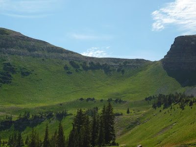
what an amazing course. Surely the best 25 mile race in the country?????

From CB Summer 2010


When I finally put the camera back into my backpack, I managed to lose the trail. How this happened still leaves me dumbfounded. The trail I was on became steep and more like a goat trail. This is a theme that would be repeated at the next pass. From up high I could see a switchback to the left, but while descending I never found the switchback. Wound up going a bit too low, took a quick break to swap socks (new shoes a tad too large..) and was about to break out a legit map when the two behind me (Sarah and Yarri) had just topped the pass. They were actually on the switchback that I needed. Laced up the shoes and ran uphill to chat for a minute then move on.
From CB Summer 2010

The running was fast, not as muddy as the last time I was in this basin. Passed a few backpackers and quickly realized I was a tad dehydrated. Chugged as much as I could before getting water from the outlet of Blue Lake (sketchy???) and going up to the pass. I never treated any of the water I got, and never carried more than a handheld bottle of water. Everyone else had hydration bladders that they only filled a time or two. Starting to reconsider this style before I run the Bear. After passing the last water source for a few miles, the trail dissappeared into what the maps call 'faint trail'. I could see the trail climbing up to the pass, so just went cross country and hit the trail at the base of the climb.

The pass:
see the little trail going up to the gap??

From CB Summer 2010


Runners who had previously run this route were complaining about this climb before the race even began. Now finally hiking it, I didn't think it was bad at all. Certainly not even close to the steep and loose stuff you find when doing some off-trail peakbagging in the area.

Back in power hiking mode and back in being blown away by wildflowers mode. The scent from the yellow flowers lining the trail to the top was overpowering. A few days later and I still haven't recovered. By how much conversation this received after the race, I doubt the other runners have gotten over the intensity either.

Sarah and Yarri starting the climb...
From CB Summer 2010


Up top:
From CB Summer 2010


Not sure why I didn't take any more photos after this, or even a proper wide-angle photo from Star Pass. Most likely I figured it was time to try to gain some time on Allen and Jake on the downhill, which wouldn't happen.

Next up was a crazy class 4 scramble on a goat trail to gain Scarp's Ridge. Turns out there was another trail on the otherside of the pass, much easier, and much safer. That was another 10 minutes wasted.

Now on Scarps Ridge and to a really fast downhill amidst more yellow wildflowers, and now the addition of tourist hikers. Jumped off the trail for many a hiker and then down to Lake Irwin. The trail junctions were really confusing, but luckily Allen had swung thru here earlier, placed a cooler of sodas(!!!), as well as a cairn at an unsigned jct. After connecting a few obscure pieces of singletrack and dirt roads, it was time for the last piece of trail.

6ish miles of the Dyke Trail. More mindblowing wildflowers. This trail would have normally been easy, but after 20 miles and 5,000 ft of elevation gained, the legs were a bit rubbery and were unhappy with all of the rolling and baby uphills. I didn't want to lose my 3rd place and knew that Sarah wasn't all thatttt far behind. A bit of focus on my form as a way of meditation, and I finished in 5 hrs and change.

Time for another huge run, this time the 4 pass loop in the Maroon Bells

Saturday, May 1, 2010

Hasta Luego

From Mainland MEX


welp. our trip is nearly over. Not enough time to write about it now, but suffice to say, we are still having fun. Some of that could be due to the fact that we are soaking up every minute of this adventure before it ends. It could also be due to the fact that Guatemala is incredibly beautiful. Either way, we have had some incredible adventures these past few weeks.

so we climbed up Volcan Tajumulco, the tallest peak in Central America. Yup...beautiful:
From Mainland MEX


We've spent more time this past week riding our bike unloaded then loaded. Lots of beautiful rides with our gear resting in the homes of our warmshowers.org hosts. This morning we rode up and around and down Lago de Atitlan. Tomorrow we leave this oasis:
From Mainland MEX

We plan to leave here tomorrow, ride to Antigua, camp at the base of the active Volcan Pacaya. On Cinco de Mayo, we will be catching a flight out of Guatemala City and starting a different life in Milwaukee. Perhaps in the future we will find ourselves flying into Columbia to ride south through the Andes....

Proper Guatemala update with photos and sappy thoughts to follow when we return to the States. Nervous for sure...

Saturday, April 17, 2010

Alta Verapaz

This is going to be tough to pull off after going nearly a month without blogging. Expensive internet, lack of towns with internet, and lack of desire to sit in front of a computer for more than 10 minutes at a time led to me avoiding the blogging thing, but here we go...

...we are in Guatemala!

Belice
After 4 months in Mexico, and a monthlong surprise visit in Belize, I thought Id never get around to write that. Mexico had much more to offer us than we had ever imagined before leaving. Belize surprised us even more. The diversity of people in that country was staggering in a way that we have grown to appreciate back in the States. There were Chinese, black Caribs, gringo expats, and refugees who fled civil wars in El Salvador and Guatemala to make a beautiful mix of cultures. The north of the country was flat, full of sugar cane fields, and overflowing with smiling people. Lots of raggae music around every corner and the cool slow speech of the Carribean Garifuna culture...speaking in ENGLISH!

We grew a tad soft in our month in Belize, speaking in our native tongue nearly all day long. We took an hour long boat ride out to an island...Caye (key) Caulker. Here the water was that dreamy Carribean shade of jade green. The locals had no cars, but cruised the streets in single speed cruiser bikes like your Granny rides. We took a sailboat out to the Barrier Reef to snorkel with whale sharks, manta rays, millions of fish, sea turtles. Lisa dove the BLUE HOLE. Most importantly we came to realize that we desperately need hammocks in our everyday lives once we have some normal sort of settled life once this cycling adventure ends. Lying around in hammocks has an effect on these people that is impossible to deny...

And then we rode west, back on the mainland, and up into Belize´s Maya Mountains. We initially had laughed at the thought of Belize having quote unquote Legitamte Mountains, but after riding the steep dirt roads to our couchsurfing friend David´s place, we had newfound respect. The longest cave system in the Americas lies under these mountains. And on top of the mountains lie tons of Mayan ruins and beautiful waterfalls. There is also a gnarly singletrack route through the wild and remote Cockscomb Basin that is begging us to return to Belize and ride....

Guatemala

After 4 days, we managed to break away from those jungle clad mountains and enter Guatemala. With our outdated Lonely Planet guidebooks, we were unsure whether or not there was a tourist VISA fee. This made it easy to get scammed out of 25 Quetzales upon entry which we realized hours later once we met other cyclists headed the other way. Oops.

Immediately after getting scammed, the pavement ended on the Belize side, and a dirt road began on the other...welcome to Guatemala. Traffic was nonexistant and the hills began to grow around us. We had assumed that this region, El Peten, would be flat and in the jungle, but it wasn´t. We rode these mellow hills north and into the steep ruins at Tikal. Late in the afternoon we got a nice sunset all to ourselves on Temple V. Early in the morning we got to stare at amazement at the colorful birds flocking and chirping in the trees surrounding Temple IV. Afterwards, we were rewarded with good conversation with a photographer who has spend the past 2 years trying to photograph the elusive jaguar in remote Indonesian islands, and now in Belize.

Then we moved on. At the time we were traveling with our Swedish cyclist friend Hannah and had a blast. Lots of joking and smiles in the green hills leading to Poptun, and Finca Ixobel. We left Hannah behind and made our way up up and up into the mountains. We were blessed with pavement to get us used to climbing uphill for hours on end for the first time in months. Once in Fray Bartolome de las Casas, the pavement ended, and the sweating began.

This is without question the toughest cycling we have done on the trip. period.

Sure there was sand in Baja. The washboards made our wrists go numb and teeth chatter. The rains of the Michoacan highlands had us shivering. But this is a different story. In our lowest gears, we find ourselves pushing the pedals as hard as we can, only to yield a speed that is barely faster than walking the bike. Factor in loose gravel, and it´s tough to even keep the wheels spinning. Pedal too erraticaly and the wheels just push thru the rock and get no traction. Not hard enough and you can´t even get into the saddle. Throw in wide vehicles trying to pass on a road barely wide enough for the both of us, and you´ve got a bit of fun. We´ve found us pushing the limits of what we can ride with loaded bikes. Hell, riding some of this with an unloaded mountain bike with wide tires would be tough.

Naturally, all of the riding is worth it. The challenge is enough to make us keep doing it, and no one really drives these roads. When we roll through tiny villages, there is nothing else going on to distract people from the gringos...filthy and sweating, pedaling through their streets. They shout GRINGO! at us. Once an entire group of schoolchildren on recess started to chant at us as we passed. We can hear the strange sounds of these Mayan languages as we ride past without the noise of other cars to cover them up. And what a strange tongue this is. The people have a really weird high pitched intonation, paired with clicking sounds, which makes their language sound more like Chinese mixed with African languages, than Spanish. Since Spanish is these peoples second, and sometimes third language, we find they speak Spanish nice and slowly....

After 2 tough days, we were rewarded with Semuc Champay. The backpackers bible Lonely Planet claims this to be the most beautiful spot in Guatemala. We can´t quite make claims like this yet, but it sure was beautiful. A raging river cuts thru the rock, goes underground, and then is spit out from under this limestone bridge further downstream. While the river is underground, there are shallow pools on top fed by springs flowing down from the mountains in the valley. These pools are beauitful shades of blue and green and perfect for swimming. Quite the surreal place, and after working so hard, we naturally had to spend lots of time soaking....

Its not tough to say that we are fully in love with Guatemala. With so much to look foward to here, we find ourselves really excited to see what each day is going to bring. We´ve already read several people say that the highway between here, Coban, to Huehuetenango is perhaps the best cycling in all of Central America. We are thinking about living with a family and sutdying Spanish for a week, way up high in a Mayan mountain village called Todos Santos. The tallest volcano in Central America is begging to be climbed. The travelers oasis of Lago de Atitlan is screaming at us to relax in hammocks after baggging volcanic peaks which surround the lake...

Hopefully the next post will have pictures from a USB card reader that is yet to be found in Guatemala. Till then, enjoy your own adventure....

Tuesday, November 10, 2009

Yet more adventure

Currently in Milwaukee, then to Atlanta, then on a greyhound to start the next adventure on November 22nd. I'm starting up a new blog at http://yumatoushuaia.blogspot.com for the trip. Hopefully I'll get a gear list and who knows what else up on there before doing internet cafe updates on the road while munching on Fish Tacos.

Till then, a ghetto map of our unplanned 'route' through Baja. Really, we'll be making it up as we go, but we start out on the west coast, know that there are 10,000 ft peaks to hike through, canyons with hotsprings, snorkeling in the Sea of Cortez, whale migrations on the Pacific side, and so much more. No telling where we'll end up, but at least this is what Baja looks like on a map!

Wednesday, October 28, 2009

Back, again.

Crested Butte has been dropping snow on me since I got here yesterday, a night and day difference from the desert environment I just spent the past month in...

5 weeks or so ago LB and I went back to UT to take care of some unfinished business that we missed this spring.

Biz like:

hiking thru the ruins of Grand Gulch
exploring the slot canyons and natural arches around Coyote Gulch
Hiking the lenght of the Paria River to Buckskin Gulch, then hanging out in my favorite spot in UT, the Coyote Buttes

and the CRUX:

hiking the last 120 miles of the Hayduke Trail from the Grand Canyon to Zion.

Naturually, it all turned into a better adventure than expected, complete with loads of photos that I'll eventually get to uploading. Grand Gulch was a nice start, and every canyon after that just got better and better. The canyon that grew as we went upstream around the Paria River might be the most colorful I've seen, and man did we get WET constantly fording the not so deep "river". Buckskin Gulch was fun, and exploring the high teepees and fun slickrock around the Coyote Buttes turned out to be one of the highlights of the trip.

Coyote Gulch was one of the greenest spots we saw in Utah, aside from the high-altitude stuff around Boulder Mtn, which we hitched over. Ferns and seeps and trees and just oh so verde down in the Gulch. Nat'l Bridges, Arches, and not too many people. Zebra and Peek-A-Boo were very beautiful, non-technical slot canyons that were nearby, and yea, lots of other surprises too.

Some technical canyoneering came next further east with some friends from CO, then we did a surprise 3 day trip in the sleeper national park in UT...Capital Reef. Really really funky landscape where all of the plateaus and peaks had a really confusing slant to them from creases in the earth's crust.

After those fun little 4 to 5 day trips, it was time for what I was the most excited about, and that was the mini thru-hike from GC to Zion, and it didn't dissappoint. Epic hitchhiking first to get out to a really remote spot on the north rim of the GC, which made us roadwalk at least 15 miles on dirt forest service roads to get out there. Every time I go back to that canyon I appreciate it more and more, and nothing can make you enjoy it more than spending the previous weeks exploring the best canyons that the area had to offer. And all of them paled in comparison, at least in terms of size. Yea the canyon always felt large, but this time I finally had a good reference point since I've seen more canyons, and it was epic. So beautiful.

Hiked down to the river in a day, rock-hopped, cursed, fell, and got free beers from rafters till we finally made the 7 miles downriver to Kanab Creek. The canyon here was green green green, full with fun "Chokestone Alley's", and the best spring I've seen in my life. 21 miles later Hack Canyon hit Kanab and we headed northwest along it. Hack was wider, and I may have enjoyed the not so claustrophobic canyon a tiny bit more. Hack finally opened up fully and we were on the Arizona Strip. FLAT and lots of dirt road walking, around 50 miles worth. I was surprised at how beautiful i found the place. could see for miles, and could see Colorado City, our only resupply point for a day.

CO City was just as strange as I was expecting it to be. One advantage of being in a polygamist town is that they have huge families, and huge familes need lots of food. Therefore, the bulk food section in the grocery store was impressive, and the food was cheap. the highlight of town for sure.

Climbed thru the canyons out of town and got up high before dropping down into Parunuweap Canyon which would take us into Zion. This canyon was probably the highlight of the trip. Fall was in full swing down there and the trees were all yellow, orange, and red, and I was all smiles. Such an inredible place. Followed a seriously sketchy route to climb up to the rim of the canyon, up onto the East Rim of Zion Canyon, camped way up high for a good view, then dropped down into the canyon to finish the trail at Weeping Rock.

I'm hoping to put together a really nice trip report with photos in the coming weeks before departing for Baja, Mexico to start the next trip, and surely the most epic yet. No ending planned, speaking a foreign language in a land that we have no knowledge or plans for....

Monday, September 7, 2009

some stuff

Getting things together for the next big adventure involving bicycles, good company, and many Latin Americans. Details later...

A bit of boredom and unlimited time on a laptop with my most recent memory card led me to upload a few pics. Cheers!
From CB hikes

From CB hikes


From CB hikes

From CB hikes

From CB hikes

From CB hikes

From CB hikes

From CB hikes

From CB hikes

Friday, September 4, 2009

Guess who's back?

It's been a busy summer here in Crested Butte, what with working part-time and constantly backpacking and biking and all. Just got back from an incredible and epic trip with LB, taking loaded bikes up and over jeep roads around town. Biked up and over Schofield Pass, down the infamous Devil's Punchbowl, down to Aspen on the rec path, then back up on jeep roads over Pearl Pass and back into town at 1 am after hours of sublime moonlit riding.

A few pics:

From Pearl Pass biking

From Pearl Pass biking

From Pearl Pass biking

From Pearl Pass biking