(Cute) girl with (cute)friend: "You're doing awesome and look great!"
Me: "If only you could feel my body right now."
::awkward silence::
Me: "ummmm, I guess that came out wrong, eh?"
GIGGLE GIGGLE GIGGLE
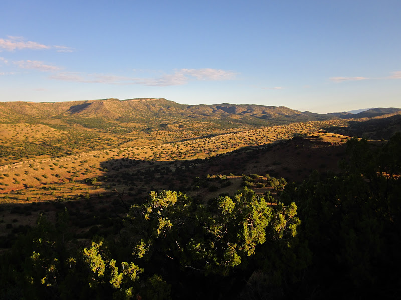
APPROACHING THE BEAR (aka The Bovine 100)
500ish miles of hitchhiking found me sharing the cars of conspiracy theorists, racist teenagers, and great conversationalists who shared my love of travel. Months of preparation and anticipation left me with only 4 hrs of sleep in my Super 8 motel room before lacing up and taking off
170 or so runners waiting in the last minutes before the 6am start
I found myself in the front 20 or so runners as we began the race, and funneled onto singletrack for the first 3,000 ft climb of the day. I was running with Matt, a guy from SLC who I'd met at the pre-race meeting. Matt had run the Wasatch 100 and enjoyed sharing stories and tips that he had learned from that run, his first 100. Soon we settled into a silent rhythm, and I was comfortably hiking at a fast comfortable pace. I'd decided to bring along my Titanium Goat carbon fiber trekking poles that I was already using. Bringing these along was a decision that would make life a hell of a lot easier when things hit the fan later on in the race...
THIS IS FUN (MILES 10-20)
Until then, everything was peachy. The trail was climbing and climbing up switchbacks out of the canyon from Logan and up to the ridge for sweet moon views at sunrise:
Once up top, we were rewarded with some phenomenal running as the ridge dipped and wove with the valley staring from below. I was finally warmed up and began to pass a few people, then taking a break to photograph, and get passed by those same people I had just passed. My pace was pretty quick, but I never felt like I was pushing things too hard. Sure, I could have gone slower, but that wouldn't have been nearly as fun. Looking back, I should have followed the advice (forgotten on race day) of "Start with what you think is a slow pace, then divide that in half". With a goal of finishing in under 24 hrs, I figured I didn't have time to be too conservative however, and wanted to run relatively quick on the flats and downs. The pace stayed quick until we started an 800 ft climb up to the first aid station at mile 10.5.
The crew at this aid station was completely hilarious, one guy even asking me if I wanted a "rubdown". I hung around for maybe a bit too long joking with these people, and when I took off, I can't remember what I saw. Things have already become a bit of a blur and the first 30 miles or so have all been mashed together in my brain. The course profile claims that there was a climb out of that aid station, and then a descent. The aid station was nestled on a saddle above the first canyon that we had climbed out of, and at some point we started a really fast descent to the next aid station at mile 19.6ish. Jake from Stanley, ID came up behind me so I pushed the pace, using him as a catalyst for higher speed and a bit of friendly conversation. Jake was a really cool cat who I would wind up running with on and off for the first marathon, and then not see him for 70 miles. Bombing down this 6 mile descent was another instance of me pushing a bit too hard and too early....classic rookie mistake.
This aid station was the first that support crews were allowed in, and it was a predictable zoo. Dozens of people on the side of the trail cheering us on as we came to refill bottles and gel containers. Here I started to get into the rhythm of getting one of the volunteers to fill up my hydration bladder with 40-50 oz of water, another volunteer to find my drop bag, and then I would refill my 2 gel flasks with the homemade energy gel waiting in my drop bag. When I was on the ball, I was always out of aid stations within 2 minutes. When I didn't care so much or worried about the clock, you could double that amount of time and blame it on good conversation. Going into the race I had intended to keep that number below one minute, but as time passed, I munched on fruit, talked, and just wanted to enjoy the entire experience...a quick adventure in under 36 hours really...
Leaving that aid station was an easy and flat 3 mile run up a craggy canyon along smooth dirt road, complete with magic light filtering thru fall leaves
 |
| From Bear 100 |
. Everyone was cruising up the slow 500 ft climb until the cows hit. Earlier in the run I asked another runner how the Bear compared to Wasatch 100. His answer was "The Bear is
cowier".
running:
stopped by over 50 cows
We'd hoped to scare the cows out of the way, but soon it became apparent that this wasn't just a group of 10 cows, and instead much more. After stepping off to the side of the road, we heard some cowboys behind on horses usher them through. Now it was time for another aid station, and another nice dose of singletrack. On the elevation profile this looked like an intimidating climb, but out on the course, it turned out to be quite tame, if not long. This is a theme that would develop over the course of the race. All summer my training was focused on getting in as much elevation gain and loss possible, usually finding me on steep 3 mile climbs of 2,000 ft. That's not quite the same as 2,000 ft climbs spaced out over 4 feet. I found myself putting my poles away during the race and running some of those ups since they seemed so much easier than I had gotten used to Again....probably a mistake that I'd realize later...
The canyon walls drew in closer and choked by trees. Not sure why I don't have any photos of this section. More memory blur and somehow the trail is back in the open again!
Lots of signs of cows now, with doo-doo infested trails and their footprints all near the boggy water-sources. Glad to not be self-supported and drinking the water through here.
Since my memory is hazy for a little bit, the least I can do is explain the general layout of the course. Canyon bottom, 2,000ft+climb to the top at a ridge, 2,000ft descent to another canyon floor, repeat. Ad infinitum. Sometimes the ascents and descents would be on dirt roads which would make the elevation change seem like a lot less. Following this pattern, the course began a nice dirt-road climb up to a high rolling section, this time with loads of sheep up high.
I played leaprog with a runner from Missouri for a while out here along a nice and rocky descent. The running was fun and I was feeling great. Rocky and narrow singletrack is always engaging, and when you throw in colorful UT foliage, it really doesn't get much better.
Somewhere in here the course climbed and again descended. And on this descent I got my first real physical worry of the run. My quads had been feeling sore between miles 10 and 20. That seemed a bit early to get sore to me, but more running shook that soreness out and I was feeling invincible. Now on this particular descent on a dirt road the underside of the arch on my left foot was delivering sharp pains to my sense of invincibility. After running a mile of this, I decided to take it easy and walk for a few minutes. Not being able to swallow my pride so easily, I began running, slowly, again. The pain returned but I just kept running. Being new at this silly 100 mile thing, I was unsure about how much pain I should just be dealing with and trying to ignore, and what pains to be truly conservative about and walk through. Hell, I didn't even know what was wrong with me!!
ATV and truck traffic began to pick up on this dusty dirt road located seemingly in the middle of nowhere. Smiles and waves were of no help, people just kept their faces smug and drove by. Just when the traffic was beginning to annoy me, the course was routed onto some low singletrack near the sounds of a small creek
With the lack of descent, my foot was fine with running on this rolling and flattish trail. Time for another aid station. Things were starting to get really hot now. I made sure to take plenty of water out of here, then rushed past the cop directing traffic around the race on Hwy89. Now the running was in nice grassy terrain, but I wasn't feeling so hot. My foot wasn't the cause for my woes, but instead my stomach was the culprit. I was feeling really bloated and it was tough to do more than a quick walking pace. This had bothered me after leaving an aid station earlier in the race, and it took a few minutes to dig at the root of the problem. Since I'd never had this issue in any of my long runs this summer, I assumed I must have been doing something different in the race. FRUIT!! I decided to eat pieces of fruit at aid stations...good stuff like melon, strawberries, and orange slices. Could that have been it?? I've got no clue, but after that point I never ate any more fruit, and I never again got bloated...
Now we were really starting to get into the race. It was around 3pm (??) and nearing the 10 hr mark. Mile 50 was starting to near it's head and I needed a bit of an energy boost. I zipped open a tiny compartment on my Ultimate Direction running vest/pack and pulled out my mp3 player. I had been trying to wait for either the 50 mile point or darkness to arrive to savor this moment. And here it was. The shuffle function played all sorts of amazing music and I was back into the run. Chewing a couple of fruity-flavored Tums helped turn my stomach around and I was feeling like $1,000,001 bucks. The trail was shaded from the heat of the sun, but not much too look at. I hadn't seen any runners for over an hour while I was struggling with my stomach, but finally I was running quickly enough to pass 3 other people, one guy looked like he was leaning over about to puke. Once the trail topped out on a ridge, there was a really fun and FAST descent to a lake. The lake was beautiful, but sadly tough to see with the now low sun burning into my eyes from that direction.
THIS IS REALLY REALLY FUNNow I'd found my second wind and decided I'd run uphill. Chatted with a man taking his son out on a backpacking trip. Not only did we talk about the beauty of this land and the lake, but he told me about the "party" every year at the Franklin Basin. Duly noted, and would become important later on. Keep in mind that he told me this at mile 51, and this aid station was 10 miles away. How quickly everything would change...
On my way up I met up with Paul, a new friend I'd made who gave me a ride from the pre-trip meeting to my motel the night before. He told me I was running better than anyone else he'd seen on the hill. Of course he may have been feeding me lines like everyone does at these races, but I was already feeling great and now felt better. Ran most of the uphill for the first time of the race and then began a really steep and rocky descent. I was singing LOUDLY along with my music and was surprised to find 2 guys behind me. How could
anyonecatch up to me with the pace I was keeping?? 10 seconds after that thought one of those guys asked me if I wanted any unsolicited advice. That advice was "don't run the uphills". Although I felt like I was killing it on the climb, I obviously wasn't going all that fast if this guy power-hiked the climb and then caught up with me on the descent. I felt like a total moron and was mentally beating myself up for the next couple of miles. It was then, in my first mental lowpoint, that my mp3 player battery died. My energy was starting to wane around mile 55, and now it really began to plummet. There was another big descent of over 2,000 miles and I mentally didn't want to do the slog. My pace dropped a bit with the decline of my positivity.
THIS (SORT OF) HURTS - MILES 60-80The sun was starting to get low, and I arrived at the 62 mile aid station just in time to pick up my headlamp. The ziploc bag waiting for me also had a long sleeved shirt, warm hat, gloves, and a windshirt, none of which I needed just yet. I was able to run out of this stop fine, but soon everything went to crap. My quads had been sore on and off for the past 40 miles...not a huge deal. Now my right knee was sending sharp pains up to my hip and I didn't know what to think. Later I came to realize that it was my IT band...a typical injury, and one at the time that it mattered I didn't know what it was... The pain was so extreme that it was tooo much for me to run the downhills. I could walk, and that was it. Uphills were better and I could easily power-hike those. But those descents were pushing tear-inducing territory. So I walked waaaayyy too slow on the descents, but made it to the aid station at mile 69. This station was the "party" station that the backpacker told me about 20 miles earlier, and I know I'd stay here for a bit. I hadn't sat done once for the entire race, but 70 miles into it, and I caved and sat down. I stayed here for 15 minutes or more while volunteers filled my water bladder, brought me broiled potatoes, candy, etc etc etc. Before this I had a fear about sitting down. If I sat would I be able to stand again??? When the time to move had come, I found that my legs felt much better. There was a really fun rock-hop across a large creek (even more fun 70 miles into a race..) , and then another big climb. I hiked really strongly, even passing a couple of people before the 2,000 ft descent to the Beaver Mtn Lodge Yurt. Feeling so great on the climb had me experimenting with running downhill again.
TERRIBLE IDEA. The pain in my knee returned with a vengeance and I found myself hobbling down the steepest descent yet. I felt like I was moving slower than 1 mph, possibly the slowest I've ever hiked in my life. With no music or daylight, there were no distractions to take me away from my frustrations. The only thing that kept me going was the knowledge that somewhere at the bottom was a warm yurt to sit down in and regroup. During the descent I caught multiple glimpses of the yurt lit up beyond. It really didn't look that far away. What it did look like was a huge drop to come, and then a climb up and out of another canyon to reach the yurt above. Definitely NOT what I wanted to see thru the trees.
Those next couple of hours spent hobbling thru the dark were a serious lowpoint, as were the throngs of people passing me by with a lot of pep in their steps. Finally at the bottom I was rewarded with a tiny ascent to the yurt, and air full of warmth. Hung out inside for over 15 minutes again, chatting, eating, and eating some more. My new theory became that my knee needed warmth so that it wouldn't tighten up. After a minute of stretching I went back into the cold. And cold it was after coming from the relative warmth of the yurt.
OK, THIS COULD BE THE LOWEST POINT OF MY LIFE (MILES 80 TO THE FINISH)No telling what happened in this stretch. My knee felt terrible and I just kept hobbling along. The cold was getting more and more intense, and my layers were proving to be justtttt adequate. There was another aid station around mile 81 that was downright frigid. To the volunteers credit, they had a large fire to help warm us up near. Here I found another guy struggling to go on. He was just staring vacantly into the fire while his father tried to get him psyched for the remaining marathon left to run. We were told that the thermometer at this aid station was reading 26 degrees, and could only be colder in the narrow canyons to come. Hearing that made the air feel even colder to me until the sun finally rose hours and hours later.
The last few hours of the night are a complete blur. I never hiked with anyone else, was very very cold, had no music, and generally can't think of anything else to complain about. An hour before sunrise I made it to the aid station at mile 85 and stayed by the fire for nearly half an hour. Even when I was worthless around mile 75 I knew that I would finish the race. Now that I was only 15 miles away, I felt no need to rush and really wanted to spend time at the only thing there was to get excited about out here: FIRE! A good group of runners caught up, one who decided to drop out so close to the finish. Finally I got bored, packed up, and walked into the coldest hour of the morning.
The sun rose. The course went to the top of a nicely lit ridge, and then dropped down into another canyon and the Ranger Dip aid station.
"Your IT Band is totally screwed up man" -Him
"Um....what's that?" - Me
Yea, apparently that knee issue is a really popular injury and one that was temporarily fixed with the compression strap that a woman had lying around to give to me. The guys at this final aid station were awesome, and even cooked up pancakes, bacon, eggs, and coffee. If I were actually racing this thing there was no way I'd put that food in my stomach, but thankfully I wasn't running. Those eggs hit the spot and I took off on the final hike with renewed vigor. People had been talking about how this climb was impossible and the toughest on the course, but it was typical hype. Yea it was steepish, but 800 ft over 1.5 miles really ain't that bad...
The final descent was completely brutal. You'd think that being at mile 94 and so close to the finish would have me fast and stoked to finish it all off. No way. With that new compression strap I made my best attempt at running. Finishing in under 30 hrs was still in the realm of possibility, but the rocky trail was pushing that realm further and further away. It was tough enough to pick me feet up off of the ground while walking. Factor in running with a knee that was tough to bend and the difficulty shot up a tad. My knee was functional for the first mile, but after that the pain returned and my hope in finishing in under 30 left.
Although it was only 7.5 miles from the last stop to the finish line, it took me over 4 hours to get there. If you're a math wizard, your brain probably already figured out that this is less than 2 mph. Pathetic right?? My thoughts exactly. Oh yea...I'd been awake for over 30 hrs at this point. My eyes were getting really heavy, and caffeine pills had finally found their limits. I began looking for a flat and shaded spot to take a quick nap. Lucky for me there were no good flat spots on this mountain other than the trail itself. Would I have ever woken up before the 36 hr cutoff if I went to sleep?? Instead of lying down, I sat down in the shade, folded my arms over my knees, and laid my head down on those arms. With my eyes closed for a couple of minutes, I rose with a trickle of added energy. At around 10 the heat started to kick in and I got even more tired. As I dropped in elevation the trail seemed to open up a lot, and I was getting baked by the sun. More and more naps were necessary. By the grace of some sort of God, I made it to the bottom of the mountain.
I could see Bear Lake oh so close, and a paved road to get there. Oh wait, there is ANOTHER climb! I saw the pink flagging branch off to the left, indicating that I needed to take an ATV trail up another hill. This made absolutely no sense since I knew I could just walk thru the gate in front of me, take a paved road to the highway, and take the highway to the lake. Was this some cruel joke by locals? We had all been warned that there were elk-hunters who weren't happy with the race and liked to remove course flagging as a form of revenge. Was this something similar??? Not wanting to cut the course short, I tried the climb anyway. My elation at reaching the bottom of the climb was immediatly reversed when I had to start another dusty climb. Would i EVER finish? Soon two other runners experienced in the ways of the Bear came behind me and confirmed that this was indeed the route, and that it was indeed a cruel, cruel joke by the race designers.
200-2,000,000 ft later, the road hit the top of the hill, went down to the river, and I soaked my feet and got some desperately needed water. Now the finish was in sight. I was (sort of ) hydrated, and to the best of my knowledge there would be no more surprise hills. In the 30 hours of this race, I had become one of those people who whine about going up and down mountains, sort of like lots of thru-hikers I've known through the years. I'd cursed rocks. Cursed my inability to pick up my feet. Now I was going to finish.
The views of Bear Lake situated in the surrounding barren landscape were beautiful all morning and afternoon. Finally I was surprised to find myself running the last quarter of a mile on that road while a few people standing around cheered me on. I'm still not sure how I was able to run again, but it was one of the surprising highlights of the run for me. All of my pain was gone as I turned off the street and ran the short stretch thru the park to the finish line.
31 hours and 54 minutes sure is a long time to be out there. I had been really frustrated with myself around mile 75 when I realized that my finish would be longer than 24 hours. After that point, I really didn't care about time anymore. Finishing was the only goal I had, and I knew that I could do it. For that last horrible stretch when I was progressing at a near-crawling pace, I whined to anyone that listened that "I would never run 100 miles again". "This is stupid" I would say. Now in the hours and days that have followed, I've changed that. In 30 hours, I felt like I had an adventure that takes days and days to experience while on a backpacking trip. The sense of total physical drain was frustrating at the time, but with flawless hindsight, there is something satisfying about giving absolutely everything that you have, and the physical feeling that followed. I'm not sure how much further I could have pushed myself out there without passing out. The heat of that 2nd day and my dehydration made passing out become a serious concern.
Is this all physical gluttony? Do I really want to put myself through the hell I experienced those last 25 miles? Was it really hell or was I just being a whiner all that time? I'm pretty sure I could do the run better if I got another shot. I wouldn't go out so fast my next time. No fruit would find it's way into my stomach. My mp3 player would be fully charged. If I'm in some of the best shape of my life again next year, my (now badly swollen) feet may be toeing the imaginary start line for another race in the American West...